Episode 7 coming soon
Has gerrymandering gotten worse?
 Crash Course
 USAFactsCrash CourseUSAFacts
Featured visualization
States set their own rules for drawing election districts, but all must follow a core set of federal requirements.
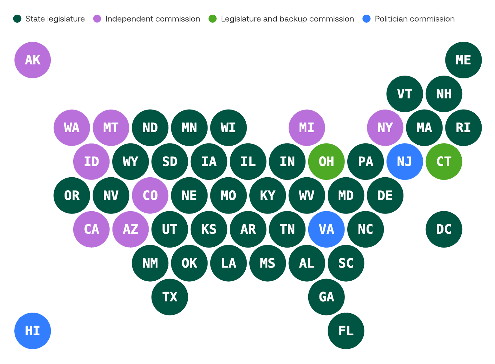
Interpret the graph
Ask yourself
Gerrymandering
Drawing congressional district lines to give one party an unfair election advantage.
Reapportionment
Post-Census reallocation of House seats to each state.
Redistricting
Changing district lines to account for lost or gained House seats, either by drawing more districts or lumping old ones together.
Packing
Lumping a certain voting population into just a few districts, so their vote essentially gets wasted when you look at the larger state or nation.
Racial gerrymandering
When race is the main factor behind how a district gets drawn.
Partisan gerrymandering
Where mapmakers use packing or cracking to give one political party an edge over another.
Description
Coming soon
Transcript
Coming soon
A monster lurks among us.
First spotted over 200 years ago, it can be recognized for its strange forms, dubious motivations, and…suspicious consolidation of voting power.
This is the gerrymander, and it’s /still/ out there, slashing voting districts, sneaking unfair partisan advantages into elections, and weakening democratic representation.
The question is: /where/ did it come from? And can it be stopped?
Hi! I'm Kousha Navidar, this is Crash Course, and we’re answering Big Questions on U.S. Government.
[THEME MUSIC]
Massachusetts Governor Elbridge Gerry drew this monstrosity of an electoral district (wings not included) in 1812, as a ploy to give his own political party an edge in elections. And he just, I don’t know, hoped nobody would notice? C’mon, dude. Looks like a-- salamander or something.
Which is exactly what everyone /else/ at the time thought, and how it got lampooned in a Boston Gazette cartoon with a name that’s stuck ever since: the “gerrymander.”
[B CAM] Imagine getting dunked on so hard, high school students have to learn it as a vocabulary term 200 years later.
[ACAM] Gerrymandering is drawing congressional district lines to give one group or party an unfair advantage in elections, often leaving bizarre shapes on state maps. And while it isn’t new, it’s only gotten more intense in today’s hotly divided political climate.
To understand gerrymandering, we have to start by understanding what a congressional district even is, and how their borders get decided in the first place.
Basically, congressional districts are these clearly defined geographical regions within a state. Each district is represented by a member of the federal House of Representatives. Every state is promised at least /one/ congressional district, and the rest are determined by population.
Since 1929, there have been 435 total seats in the House. And as each state’s population changes, so does their share of those 435 total seats. That process is called reapportionment—the post-Census reallocation of House seats to each state.
After all, a lot can happen in ten years! Cool jeans become dad jeans, dad jeans become cool jeans, and state populations shrink or grow. And based on those population changes, and resulting representative shifts, states have to be redistricted, where district lines are changed to account for lost or gained House seats, either by drawing more districts or lumping old ones together.
[B Cam] Fun! Art project! This is why we need funding for the arts.
ALT: Fun! A cartography project!
[A CAM] Even if a state doesn’t lose or gain seats, the districts /themselves/ have often either lost or gained residents. That’s a reason to redraw district lines, too, thanks to the 1962 Supreme Court decision in Baker v. Carr. This helped establish the “one person, one vote” principle when it comes to congressional districts and representation in the House, which means all of a state’s districts need to be about equal in population.
Otherwise, a vote in a less populous district carries more influence than a vote in a heavily populated one. (Don’t think too hard about how that principle applies to presidential elections…or the Senate…)
Exactly /how/ these new district lines are drawn is up to individual states– sometimes it’s decided by state legislators themselves, or sometimes by specific commissions. But it all sounds simple enough to do… Oh, I’m being told no, it’s definitely not.
Thankfully, we’ve got our brilliant Congressperson John J. Johnson to straighten us out.
[BEGIN TANGENT]
[Congressperson] Oh, Kousha, stop! You’re the brilliant one!
[Kousha] No, you!
[Congressperson] No, you!
[Kousha] No, y–
[Congressperson] I really haven’t got the time for circular flattery today.
[Kousha] –sorry.
[Congressperson] Now, when it comes to understanding how this all goes down, it’s helpful to look at an example of district lines drawn as they should be, by people with good intentions: welcome to the beautiful state of Koushachusetts!
When it comes to congressional mapmaking, first, we’ve got to consider geographic compactness. Ideally, we want tiny, boring-shaped districts with smooth boundaries. Think circles. Squares. No salamanders, centipedes, or flying robot tigers. But we aren’t just making squares for the sake of squares; by keeping our shapes as basic and boring as possible, it helps us be as neutral as possible with our groupings.
But as much as we like being boring, random, and nonpartisan, there are plenty of other things to consider when it comes to Congressional mapmaking– like population density. Plus, some states require mapmakers to consider preserving communities of interest. These are the neighborhoods, ethnic communities, and industries where people have common interests. This allows communities to actually vote for what’s best for them.
At the same time, we /also/ try to respect political & geographic boundaries already in place. Where are the county lines, city lines, and cores of the previous districts? What about the natural features like rivers and mountain ranges?
But then there’s partisanship—and this gets tricky. We /do/ want to take political leanings into account, to an extent, because we want to keep lively competition between the parties in each district. That means ensuring a roughly even balance of Anti-Arugula Party supporters and Make Arugula Great Again supporters.
But there’s also the argument that partisan balance within an individual district doesn’t matter so much, as long as there's a balance of power between /all/ the districts.
It’s a lot to consider, and whatever choice we make about where to draw the lines, it’s going to reflect what /we/ choose to prioritize as the line-drawers. All of which makes this mapmaking thing not so easy. Excuse me, I’ve gotta take this.
[END TANGENT]
/Wow/. Ok first, Koushachusetts? Great place to live. [looking off to the distance] I hear every day is Taco Tuesday.
[ACAM] But second, and more to the point of what we’re all doing here today, with so many conflicting priorities, it seems legitimately very difficult to draw district maps that make everybody happy, even with the best intentions.
And when intentions /aren’t/ so pure, well, that’s when you get this guy. Gerrymandering happens when the folks drawing the district lines /purposefully/ go against guidelines to dilute certain communities’ voting power, and enhance others.
Gerrymandering happens in two main ways. The first is cracking, splitting a certain voting population across many districts, so their vote stays weaker in all of them. The second is packing—lumping a certain voting population into just a few districts, so their vote essentially gets “wasted” when you look at the larger state or nation.
And so far, I’ve been speaking of gerrymandering as if it’s just one beast. But there’s actually two primary kinds, treated very differently under the law.
In racial gerrymandering, race is the main factor behind how a district gets drawn. Historically, and into the present day, it’s been used to dilute the voting power of racial minorities, especially Black citizens in the South.
Following the abolition of slavery in the US, racial gerrymandering took a huge toll on voters of color in the South. Because of the Voting Rights Act of 1965 (which outlawed racial discrimination in voting, and therefore racial gerrymandering), it’s gotten harder to get away with. But not for lack of trying. In 2023, federal judges found that Alabama’s proposed congressional district map intentionally, unconstitutionally, and /illegally/ gerrymandered their district map to weaken the Black vote, and made them throw it out. And in 2026, the Supreme Court ruled that the use of the VRA to purposefully protect racial communities of interest was actually /un/constitutional– making it pretty much impossible to challenge racial gerrymandering in the future.
But while racial gerrymandering is still /technically/ illegal, partisan gerrymandering is more of a gray area. That’s where mapmakers use packing or cracking to give one political party an edge over another.
And this is something /both/ sides do. Just look at the new map red-state Texas came out with in 2025, and blue-state California’s retaliation.
When partisan gerrymandering is going on, you’ll often see lopsided election results that don’t line up with the popular vote. Take North Carolina: in 2024, Republicans won 10 out of 14 House seats—but only got about half of the actual votes across the state. Or Illinois: that same year, Democrats held 14 out of 17 House seats, but only got about half votes.
And don’t forget: it’s often state legislators themselves who draw district lines. So with the governor’s sign-off, it can be really easy for the party in power to help themselves stay in power through partisan gerrymandering.
[broken computer gag: Kousha fights with computer, cut to color bars]
So, gerrymandering definitely isn’t getting /better/. But is it actually getting /worse/? And could it be to blame for our more and more polarized political vibe we’ve got going on?
There’s definitely an argument that gerrymandering is driving polarization, splitting Democrats and Republicans further apart by helping parties secure certain seats as “safe.” The thinking goes that once a party’s a shoe-in for a specific seat, the representative filling it will have more incentive to listen to their own party who voted for them —and way less reason to listen to the toothless opposition who didn’t.
But there’s also decent evidence that gerrymandering is actually more of a /symptom/ of how polarized we’re getting, not the driving cause.
[B CAM] It’s the tummy ache itself, not the entire sleeve of Oreos I ate last night that caused it, you know?
First, it’s not /only/ those super gerrymandered districts electing representatives that are more extreme than the norm. Plus, jurisdictions whose lines /don’t/ change, like counties, are /also/ leaning more heavily toward one party or another these days. So, polarization has found its way into our politics in other ways than just partisan redistricting.
But even if the gerrymander is more a /symptom/ of polarization than the cause, as partisanism escalates, so too does the gerrymander. It’s big, bad, antidemocratic news. Not only does it suppress voters’ voices, but it makes us trust Congress—and our system of government in general—a whole lot less.
Now, if you’re thinking, “this whole gerrymandering thing sounds incompatible with democratic principles,” you’ve got something in common with the 2019 Supreme Court case Rucho v. Common Cause, which agreed that partisan gerrymandering is, and I quote “incompatible with democratic principles.”
But the Court /also/ ruled it’s not their place to stop it. They gave the logic that federal courts can only stop gerrymandering based on innate individual traits we /can’t/ choose, like race, not the ones we can, like your political affiliation.
But there /are/ other options on the table to put a stop to partisan gerrymandering. Rucho v. Common Cause made it clear that Congress and the states /can/ pass laws that limit gerrymandering. A lot of them just…haven’t.
But some states /have/ moved to do other things to keep gerrymandering in check, like changing who’s in charge of drawing the lines in the first place. Some states appoint advisory commissions to the politicians who conduct district mapmaking, while others put the task toward a mix of elected officials and independent citizens. And still others use independent redistricting commissions whose members /can’t/ be elected officials.
And while commissions aren’t perfect, they do lower the odds of partisanship making a map really unfair.
Another possibility is just doing away with districts altogether and adopting proportional representation—where representatives would be allocated to each party based on a popular vote. So, if a party gets half the votes, they get half the seats, bing bang boom. It would need an entire constitutional amendment to happen nationally, which seems pretty unlikely, but supporters argue it’s one way we could finally get rid of a pesky problem that’s been dogging our republic for over 200 years.
The gerrymander is a beast brought into our country not by the Constitution, like the Electoral College, or by animal smugglers, like the giant African land snail, but by our parties’ desires to dilute the voices of those who disagree. And the more we feed it with our own hyper-partisanship, the more it will gnaw away at our democracy.
[ALT] The gerrymander is a beast brought into our country not by the Constitution, like the Electoral College, but by our parties’ desires to dilute the voices of those who disagree. And the more we feed it with our own hyper-partisanship, the more it will gnaw away at our democracy.
There’s no easy way to draw a Congressional map, but one thing is for certain: we’re dealing with a system where, for the most part, politicians themselves are the ones wielding the pen, and the power. And while getting rid of gerrymandering won’t be easy, it will be worth it. Because democracy /needs/ disagreement, different voices, and healthy competition in order to achieve /actual/ representation of the people.
Speaking of representation – next time, we’ll ask: if Congress is supposed to represent “the people,” then why are so many Congressmembers old, rich, and white? I’ll see you then.
[OUTRO]
This episode of Crash Course Big Questions on U.S. Government was produced in partnership with USAFacts, a non-partisan civic tech project that makes government data easier to understand.
Thanks for watching this episode of Crash Course Big Questions on U.S. Government, which was filmed at our studio in Indianapolis, Indiana, and was made with the help of all these nice people. If you want to help keep Crash Course free for everyone, forever, you can join our community on Patreon.

Coming Nov. 3, 2026
by Crash Course
Teaching the full Big Questions about US Government series? Get materials for every episode.
Subscribe to get classroom materials new Crash Course episodes, and USAFacts data for teaching civics.

