After each decennial census — a count of the US population taken every 10 years — federal, state, and local election district boundaries are redrawn to reflect population shifts. This process is called redistricting. The way those lines are drawn can affect political representation. When maps are designed to give one political party or group an unfair advantage, the practice is called gerrymandering.
Each congressional district elects a single representative. The census also determines how many seats each state receives in the US House, so a state’s population growth or decline relative to the rest of the country can shift the number of districts it draws.
States don’t have to wait 10 years to adjust these lines. In recent cycles, several states have had mid-decade redistricting, triggered by judicial rulings or political processes. In the 2026 midterm, nine states will have congressional districts that differ from 2024.
Federal law sets several requirements for congressional districts, while states establish additional criteria for how lines are drawn and who draws them.
Who draws the congressional boundaries in each state
In most states, the state legislature is directly responsible for redistricting. Other states delegate this task to specialized bodies.
- Politician commissions are composed of elected officials or political party leaders, often structured as bipartisan bodies with representatives from major parties.
- Independent commissions are typically made up of citizens who don’t hold public office, registered lobbyist positions, or political party roles.
- Legislature and commission models combine state legislators and independent citizens to co-manage the process.

How does redistricting law differ by state?
Redistricting is shaped by a mix of federal rules and state requirements. Each state establishes its own criteria in state law or its constitution. Here's a look at some of the more common requirements.
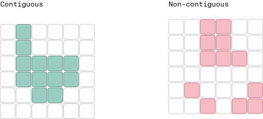
Districts may be required to be contiguous.
Federal law does not require congressional districts to be contiguous, and some states have no state-level requirement either. In practice, districts are generally drawn so that no part is separated from the rest by another district.
A contiguous district allows a person to travel from any point in the district to another without entering a different district. A district can’t have detached islands of territory.
States differ in how they treat areas separated by water. Some require a bridge, ferry, tunnel, or other transportation connection for those areas to count as contiguous, while others do not.

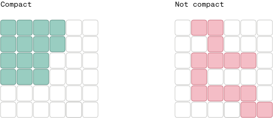
Districts may be required to be compact.
Compactness means residents within a district live as close to one another as reasonably possible. A compact district favors regular, consolidated shapes over long, narrow, or jagged designs that stretch across large geographic areas.

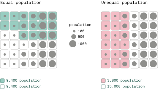
Districts must have equal populations.
Federal law requires congressional districts within a state to have populations as nearly equal as practicable. Small differences may be permitted, but states generally must justify avoidable population deviations based on legitimate redistricting goals. This rule upholds the "one person, one vote" principle, which comes from Article I, Section 2 of the Constitution.
State legislative districts must follow the same one person, one vote principle — grounded in the 14th Amendment's Equal Protection Clause — though courts allow somewhat more variation between them.

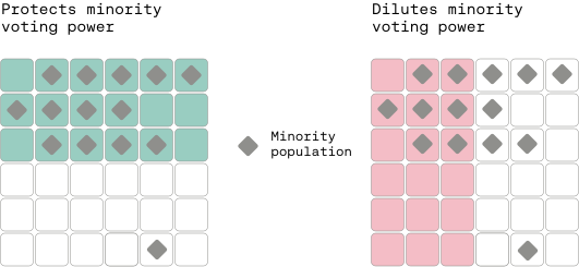
Districts should be designed to protect minority voters.
Section 2 of the federal Voting Rights Act applies nationwide. It prohibits district maps that unlawfully weaken the voting power of racial and covered language-minority groups.
To comply, mapmakers must ensure minority populations have an equal opportunity to elect candidates of their choice. The law doesn’t require representation to match a group’s share of the population.
Where specific demographic and legal criteria are met, mapmakers have drawn "majority-minority" districts — areas where a racial or language minority group makes up a majority of the citizen voting-age population — to prevent vote dilution.
The 14th Amendment's Equal Protection Clause limits how much states can rely on race when drawing district lines. In Louisiana v. Callais (2026), the Supreme Court held that Louisiana could not justify making race the predominant factor in drawing a district because the Voting Rights Act did not require the state to create that majority-minority district.

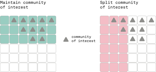
Districts shouldn’t split communities of interest.
Many state laws require mapmakers to preserve communities of interest: groups of residents who share common policy concerns, economic ties, or social and cultural interests. Examples include urban neighborhoods, agricultural regions, coastal areas, or industrial corridors.
Keeping these communities intact within a single district gives residents a unified voice when advocating for shared local needs at the state or federal level.

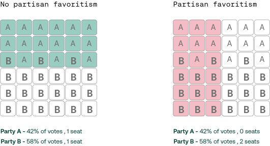
Districts shouldn’t be designed with partisan favoritism.
Federal courts generally cannot strike down a map solely because it is a partisan gerrymander, but several states prohibit drawing districts designed to favor or disfavor a political party, incumbent legislator, or candidate. These rules restrict intentionally skewing district lines to create safe seats or an unfair electoral advantage.

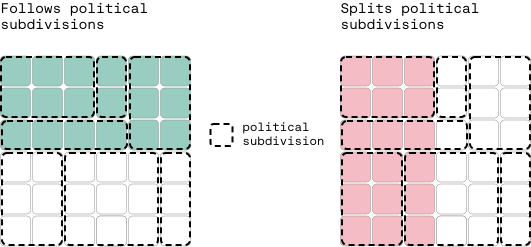
Districts should follow existing political subdivisions.
Mapmakers are often required or encouraged to respect existing political subdivisions, such as counties, cities, towns, and voting precincts.
Keeping political subdivisions intact helps simplify election administration. It also prevents voters in the same city or town from being split into different congressional or state legislative districts, making it easier for residents to identify their representative.

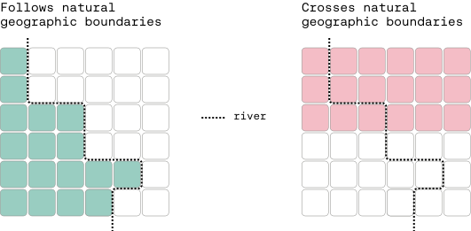
Districts should align with geographic features.
Redistricting bodies are also often instructed to align district boundaries with major geographic features whenever practical. Prominent natural features — such as rivers, mountain ranges, lakes, and oceans — provide logical, recognizable boundaries.
Using physical geography to define borders also prevents districts from awkwardly spanning major natural barriers that divide daily life.

And others...
Beyond these principles, states often apply additional rules.
- Many require nesting — fitting lower-chamber legislative districts entirely within Senate districts.
- Others require preserving cores of prior districts to maintain continuity for voters.
- Some states direct mapmakers to consider electoral competition.
- Others prohibit prison gerrymandering by counting incarcerated people at their home addresses, rather than at the facility where they’re held.
Additionally, six states (Alaska, Delaware, North Dakota, South Dakota, Vermont, and Wyoming) have a single at-large seat in the House of Representatives. Because their entire population is represented by one statewide congressional district, they skip congressional redistricting entirely. State-level rules still apply to their state legislative maps.
Choose a state below to see all its criteria.

